Latest News


Hurricane Beryl to begin affecting Jamaica before daybreak
July 02, 2024
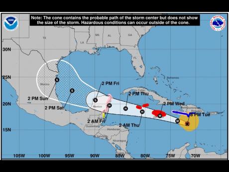
The Meteorological Service of Jamaica says the outer bands of Hurricane Beryl will reach Jamaica before daybreak Wednesday, beginning with sections of eastern and north-central parishes.
It says this will gradually spread across the island as the centre moves closer to the coast, and will be accompanied by periods of strong winds, gradually increasing to hurricane force during the morning.
Dangerous storm surges and battering waves will also be generated mainly along coastal areas of eastern and north central parishes.
The centre of the hurricane is expected to move very near or over the island’s southern coastline tomorrow afternoon.
A hurricane warning remains in effect.
Beryl remains a Category 4 hurricane and currently has maximum sustained winds are near 250 km/h (155 mph), with higher gusts.
Weakening is forecast during the next day or two; however, Beryl is forecast to be at or near major hurricane intensity while it passes near Jamaica on Wednesday and the Cayman Islands on Wednesday night.
Hurricane-force winds extend outward up to 65 km (40 miles) from the centre and tropical-storm-force winds extend outward up to 295 km (185 miles).
We want to hear from you! Email us at star@gleanerjm.com and follow @thejamaicastar on Instagram and on X @JamaicaStar and on Facebook: @TheJamaicaStar, or on Whatsapp @ 876-550-2506.